Background
The war in Sudan is not only razing entire cities and destroying infrastructure with widespread casualties, it is negatively impacting the environment and threatening to create a toxic legacy for generations to come. The impact of war on ecosystems and natural resources is often overlooked when compared to the social and human harms of armed conflict. However, environmental impact has repercussions that extend beyond the boundaries of national territories and current generations. The war in Sudan has killed thousands of people, displaced millions and caused widespread environmental damage. Armed conflicts damage both the environment and the communities that depend on its natural resources, with direct and indirect environmental impacts and the collapse of institutions leading to environmental risks that can impact on people’s health, livelihoods and security. Such consequences can then weaken peacebuilding in the post-conflict period. There is an urgent need for environmental damage assessment efforts to monitor and record the character, magnitude and significance of conflict-related environmental impacts and prepare environmental management plans to mitigate environmental impacts.
By any measure, Sudan Current conflict has been a humanitarian catastrophe. But beyond death, displacement, and human suffering, this war — like all wars — is a disaster for the environment. The environmental consequences of the conflict are as extensive as they are grave, but monitoring impacts, confirming reports, and transmitting verified information is extremely difficult. Aiming to counter misinformation and disinformation UKCC is planning to establish Sudan War Environmental Consequences Observatory (SWECO). The observatory plan to document the impacts of the war and disseminate the most accurate, carefully-vetted information obtainable in Arabic and English.
The Observatory will be committed to environmental protection, peace, and human rights. It will be collecting, vetting, and writing environmental reports to be published as a resource for scientists, activists, journalists and civil society.
The environmental consequences of the war in Sudan fall into two main categories: direct and indirect impacts. Unlike the bombing, fires, pollution, and immediate physical damage that can be seen and measured, there are more indirect impacts, such as how the war affects food security, current and future generations education and livelihoods, refugees’ crisis in neighboring countries as well as impact on the world climate agenda.
The need for the observatory grew out of a sense of despair and desire to apply knowledge, technical capabilities and experience in a meaningful way that would increase understanding and foster an exchange of ideas and possible solutions while building awareness of the lesser-known environmental consequences of the war.
It is important to consider the broader environmental costs associated with post-war reconstruction and to develop more sustainable, forward-looking solutions in order to avoid destroying what remains in nature. With so much of Sudan’s industry and infrastructure in ruins, difficult decisions will need to be made when rebuilding.
The observatory will include a Satellite based remote sensing unit supported by field groups. The observatory will use very high-resolution Satellite images with analysis validated by members of the Observatory supported by volunteers working on the ground inside Sudan. This allows the observatory to gather raw data on the war’s impacts and to track media and official coverage and assess its validity.
It is of critical importance to monitor and document the war’s environmental impacts. These impacts can harm the health and well-being of both humans and wildlife, disrupt ecosystems, and contribute to climate change. It is vital to fund environmental protection and conservation efforts, to ensure that Sudan can continue protecting its environment. The observatory will help raise awareness of these factors, inform the recovery process with facts on the ground and help to conserve Sudan’s natural environment for future generations.
Crisis overview
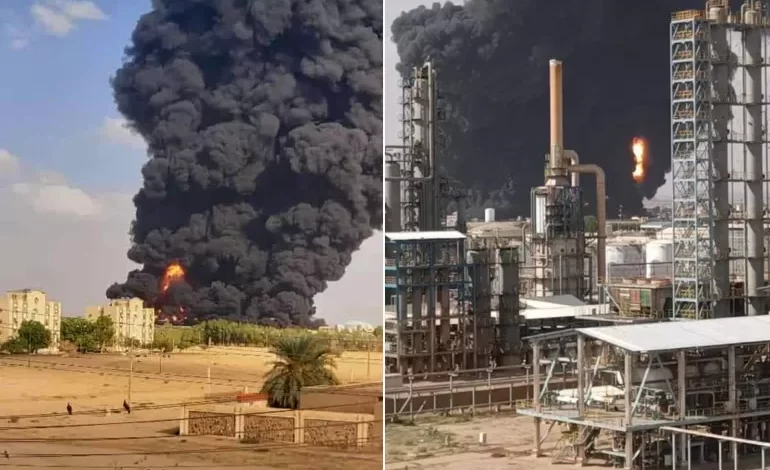
On 15 April 2023, clashes erupted between the Sudanese Armed Forces and the Rapid Support Forces (RSF) in multiple areas of Sudan. Multiple ceasefires have created temporary lulls in fighting, but violence continues. The most affected states are Khartoum, Al Jazirah, Central Darfur, North Kordofan, South Kordofan, West Darfur, White and Blue Nile, West Kordofan and Sennar. Thousands of people have been killed and millions been displaced inside and outside Sudan. The conflict has seen damage across many regions of the country, with incidents at power plants, energy infrastructure, including oil storage tankers, oil refineries, fuel and gas stations, industrial and agro-processing facilities. The result has been multiple air pollution incidents and potentially serious contamination of ground and surface waters. Water infrastructure, including pumping stations, purification plants and sewage facilities, has also suffered significant damage.
The displacement, access constraints, and destruction of infrastructure resulting from the conflict have affected people’s access to essential items, such as food and water. Million currently need assistance with basic human needs. Devastating environmental impact of the war include:
- Education: An estimated 19 million children in Sudan are out of school. At least 10,400 schools shuttered in conflict-affected areas. If the war continues, no child in Sudan will be able to go back to school, leaving them exposed to immediate and long-term dangers, including displacement, recruitment into armed groups and sexual violence. Sudan is on the brink of becoming home to the worst education crisis in the world.
- Livelihoods: The war has caused severe humanitarian catastrophe, destroyed key infrastructure, and constrained trade and production activities. Moreover, it disrupted access to public utilities, financial services, and markets, hence, triggering considerable scarcity of goods and services. Studies to assess the economy wide implications of the conflict on economic activity, productive resources, and livelihoods revealed that the economy shrunk by more than half its size before the war with household incomes declining by a similar percentage in urban and rural areas and the number of poor people will increase by millions as the war continues.
- Lack of water supplies, Damage to infrastructure and water shortages: The destruction of water supply infrastructure is one of the direct consequences of the current conflict. The fighting has partially destroyed several water treatment plants and affected water pumping stations.
- Impact on health infrastructure/disruption of medical supplies: The conflict has significantly affected the Sudanese health system including destruction, looting and devastation of hospitals, clinics and medical laboratories with associated deaths and fatal injuries. As a consequence, disease surveillance, health laboratories, and medical teams are considerably limited throughout the country. Besides its effect on care for the sick and war casualties, this disruption risks aggravating outbreaks of diseases such as cholera, malaria, dengue fever, and polio. The inability to adequately monitor suspected cases, test them in laboratories, and treat them early can significantly increase mortality and transmission.
- Poverty and livelihood disruptions: Given the current conflict, poverty incidence is likely to rise because of the disruption of livelihoods in conflict zones. The current conflict has also disrupted several local markets and made it more difficult to sustain supply chains. Staple grain prices are expected to increase substantially above the 2022 average. These price increases come at the same time as the almost total disruption of rural livelihoods in many areas and the emergence of high levels of displaced people with limited access to their livelihoods.
- Social Cohesion: This conflict is likely to generate and reinforce existing community and inter-ethnic tensions. The war will have a regretful long term impact on peaceful coexistence of different eccentricities in Khartoum and Sudan in General. The warring factions are associated with distinct tribes, local and regional. Atrocities in Darfur is well documented. The looting and sexual violence in Khartoum and Jazeera will have a drastic impact of peaceful coexistence in any post conflict period.
The ongoing conflict have impacted Sudanese people’s health, livelihoods, access to basic services, life savings and security. Such consequences will weaken peacebuilding in the post-conflict period and will devastate the hopes of current and future generations in Sudan. Social cohesion need to be urgently addressed by both the international community and locally recognizably entities, that are acceptable to all ethnic factions, prior to any peaceful resolution to the war.
The use of Satellite images in war monitoring
Satellite images can be employed by a wide range of human rights, humanitarian, and peacekeeping actors to mitigate the impact of violence or support the resolution of armed conflicts. Humanitarian actors, like the International Committee of the Red Cross, utilize satellite images to verify reports, monitor critical infrastructure, and analyze hostilities during conflict situations. The uses of satellite imagery in war’s impact studies received much public attention during the 1991 Gulf War between Iraq and Kuwait, due to extensive interest in the war’s environmental consequences spurred by the massive impacts resulting from vehicle movements, hundreds of oil well fires, and numerous oil lakes. Since then, satellite imagery was utilized to show war impacts, initially concentrated on the immediate impacts of violence and military action by monitoring villages, urban infrastructure, housing, and urban built environment. On the other hand, the mass displacement of local residents; re-vegetation of agricultural areas and construction of new service roads as a result of war lead to changes in land use and land cover which can be detected easily using remote sensing devices.
The Gulf War between Iraq and Kuwait, was one of the first large scale environmental disasters that was closely monitored by remote sensing technology such as multiple sensors from relatively coarse AVHRR imagery to finer spatial resolution Landsat and SPOT data, which were used to map, evaluate, and monitor changes dealing with urban development, vegetation, coastal wetlands, and sand sheet surface differences and to document the effects of the 1991 Gulf War in terms of oil lakes, oil spills and burning oil wells. Further analyses were also used to identify the distribution of burning wells in different oilfields and produced estimates of flow rates and emissions of gaseous pollutants and particulates by incorporating the different spatial and temporal resolutions of AVHRR, Meteosat, Landsat Thematic Mapper, and SPOT data.
Remote sensing satellites were used to document the war’s impact on the environment in Iraq. Multispectral imagery of Landsat and IKONOS was applied by UNEP in 2003 to show the effects of the oil trench fires on the environment around Baghdad in March 2003 at the start of the second US-Iraq conflict. decision tree analysis to classify multi-temporal Landsat TM and ETM+ imagery to monitor the cultivated area in central Iraq, during three decades of war. Brasington in 2002 applied satellite imagery as well to document the effects of war on the Mesopotamian Marshlands in the southern part of Iraq. Also, the effect of war on land vegetative cover in Saudi Arabia was studied due to the second Gulf War.
Specific Objectives
Prime Objectives of the Observatory
The Observatory is planning to monitor and record the character, magnitude and significance of the conflict-related environmental impacts. The current situation is very alarming. Major efforts is required to highlight the toxic legacy of the conflict and raise awareness among all stakeholders. The observatory will use very high-resolution Satellite images backed by data from the ground and conduct a quantitative assessment to develop damage assessment inventories for damage to key infrastructure facilities including:
- An inventory of all damages to educational facilities (schools, universities, technical colleges). Hope is fading among about 19 million students in Sudanese schools and universities, amid great frustration and fears about the future of these students, some of whom were about to graduate.
- An inventory of all damages to healthcare facilities (hospitals, clinics, pharmacies, medical laboratories, medical research centers). Sudan’s health system was severely affected by multiple attacks on healthcare facilities and workers, closure of hospitals, occupation and looting of medical facilities.
- An inventory of all damages to the agriculture sector. The agriculture sector remains the biggest employer, representing source of employment and incomes for about two-thirds of the Sudanese population. The observatory will conduct remote sensing analysis. This will use satellite imagery to:
- monitor the Normalized Difference Vegetation Index (NDVI) in agricultural areas across Sudan, and compare the average vegetation to previous years, serving as a rough proxy for potential agricultural production.
- estimate the impact of the war on Irrigated areas and large-scale industrial farms that rely on fuel-powered machinery or intensive early funding. This involves monitoring irrigation infrastructure, dry and refrigerated storage and agriculture products processing facilities.
- monitoring the key producer states for sorghum, wheat, millet and groundnuts.
- understand and anticipate potential impact of conflict on agriculture across the entire country; and
- reduce vulnerability and increase income and food security for farmers.
- An inventory of all damages to the animal resources and poultry sectors within Khartoum State and the producing states. The inventory will include: Poultry houses, animal dens, hatcheries, veterinary clinics, slaughterhouses and specialized feed factories. The inventory was requested by the Ministry of Animal Resources to adopt policies aimed at mitigating the conflict devastation of the sector and maintaining food security.
- An inventory of all damages to the industrial sectors including the food, textile, building materials, pharmaceutical, machinery and vehicle factories and supporting utilities. The inventory is a must for any government policy making regarding livelihood, food security and rehabilitation efforts for the post conflict era.
- An inventory of damages to oil production, refining and Distribution facilities. UKCC is currently cooperating with the Ministry of Energy and Petroleum to environmentally audit oil production companies and ease tensions in affected communities.
- An inventory of all damage to the governmental and banking sectors and the voluntary work sector. The inventory includes infrastructure, facilities, and equipment.
- An inventory of all damages to the service sector (electricity, water, communications, and waste facilities). The inventory includes infrastructure, facilities, and equipment.
- Monitoring the Nile forests that extend on both banks of the Blue Nile from the south of the Sennar Reservoir to the north of the Rusayris Reservoir, at a distance of 200 linear kilometers. In the absence of alternative these forests have been subjected to unjust cutting, even though they have a technical management plan and they represent a complete ecosystem with economic and social benefits.
- A survey of damage to the Gum Arabic belt to assess the impact of the war on one of Sudan prime economical resources and a revenue source for millions of people.
- Conducting a survey of the environmental damage to all sectors in states directly or indirectly affected by the conflict.
Secondary objectives of the Observatory
- Informing residents about potential health and safety threats. This is important not only for people who are directly in the affected areas, but also for those who fled and may want to return home. Migrants are enduring a lot of hardships and they are under a lot to pressure to return, particularly to Khartoum. People should understand whether or not it is safe to do so. A lot of effort is required. Raising awareness among the affected communities require collaboration between the international community, the academia, the media and the health authorities in Sudan.
- Providing regular update on the environmental situation in Khartoum to facilitate the return of its residents. In light of the current environmental situation resulting from the impact of this war unattainable in the short or medium term, as there are serious security, planning, structural and social conditions that prevent the return of its population. The Observatory will assist in facilitating the return of its inhabitants in an orderly and safe manner.
- Provide information and support for different States to resettle returnees: There is an urgent need for major efforts from different states in Sudan to resettle large numbers of returnees from Khartoum, especially in safe productive states which are in dire need of human resources necessary for development. The Observatory will provide essential information for different states to complete emergency plans to increase their capacity to re-accommodate returnees in their origin regions. This is likely to alleviate enormous pressures on the humanitarian situation and help to diffuse ethnic tensions in the capital which are further aggravating the ongoing war in Sudan.
War Related Damage Assessment
The war caused significant damage to urban infrastructure, landscape, and loss of human life. Satellite based remote sensing plays a key role in rapid damage assessment, post-disaster reconnaissance and recovery. Satellite based remote sensing will be complemented with field data collection.
The center will use very high-resolution optical images and a quantitative assessment to develop damage assessment map. Remotely sensed earth observations (EO) have long played a key role in the communication of pertinent damage information post natural disasters, especially information related to surface effects and damages to infrastructure. Medium resolution optical images (e.g., Landsat, ASTER, and Sentinel-2) have provided data for a more general interpretation of damaged areas in disaster zones. The new generation of high-resolution optical images (e.g., IKONOS, QuickBird, Geo-Eye, and the WorldView series) have enabled building scale damage detection post disaster using pixel or object-based change detection techniques. The advances in deep learning algorithms, such as deep Convolutional Neural Networks (CNNs), have also been instrumental in damage recognition. For instance, the release of xBD alongside the xView2 Challenge, which provide large-scale satellite imagery, building polygons, and ordinal labels of damage level for various natural disasters, have been great contributions to the architecture and training strategies of building damage mapping. In the war in Ukraine, satellite imagery was used in to provide timely damage assessments and facilitate relief efforts by various humanitarian organizations. The locations and the density of the damage contained within different study areas, especially the number of damaged buildings, can serve as a useful proxy to estimate the effects of the war in real time. Such information will help to expedite the recovery phase once the war comes to an end.
In most instances of war, indirect war fatalities tend to surpass the number of direct war fatalities, especially where the infrastructure is heavily damaged and destroyed. The social and physical direct and indirect impacts of war have historically been studied and itemized after the cessation of the conflict. However, with the help of modern technology and the advances in global satellite imaging—wide area coverage, relatively low cost, and regular revisit time—journalists, scientists, researchers, and engineers in Sudan can, through the observatory have access to near-real time imagery for rapid reconnaissance of impacted regions and can quantify damage to infrastructure.
Environmental Management Plans (EMPs)
The Observatory role will not be restricted to monitoring it will help formulate Environmental Management Plans (EMPs) that addresses negative impacts, the following steps will be taken:
1. Impact assessment: Conduct a comprehensive assessment of environmental and social impacts in the post-war context. This should involve identifying potential sources of pollution and understanding the social dynamics and vulnerabilities of affected communities. Sources of Information need to provide a more complete picture of the environmental impacts of the war taken from research and the other parts of the assessment (e.g. remote sensing, GIS/ArcView mapping and analysis), and identify additional impacts that have yet to be determined.
2. Stakeholder engagement: Consult and involve affected communities, NGOs, and relevant government agencies in the formulation of the EMPs. This ensures that their perspectives and concerns are adequately considered.
3. Prioritize mitigation measures: Based on the impact assessment, prioritize the mitigation measures that will have the greatest positive impact on the environment and social well-being. This can include measures such as waste management, restoration of ecosystems, and provision of basic services to displaced populations.
4. Monitoring and evaluation: Develop a robust monitoring and evaluation framework to track the implementation and effectiveness of the EMPs. Regular monitoring and evaluation help in identifying areas that require adjustment or improvement.
5. Capacity building: Provide training and capacity building programs to local communities and relevant stakeholders to enable them to actively participate and contribute to the implementation of the EMPs.
Overall, the EMPs aim to restore and protect the environment, address social challenges, and promote sustainable development in post-war contexts.
Tailored, data-rich maps identifying the intersecting urban and climate risks are vital to understanding where the greatest threats to the cities’ most vulnerable populations, and where to build infrastructure like sewers, clean water systems, and drainage to help manage and sustain the new influx of people fleeing conflict. It is a small but critical step to mitigating widespread suffering across the region in times of crisis.
University of Khartoum Consulting Corporation (UKCC)
UKCC was established in 1998 to contribute to the economic and social development of the Sudanese people and build bridges between the university and society. Our most valuable resource is a great dedicated multi-disciplinary world class team which include more than 890 Consultants who work on full or part-time basis (most of them are UofK staff members). UKCC work very closely with the university Institute of Environmental Science. Some of our marked accomplishment in the environmental field in the last five years Include:
- Sharif Petroleum Environmental Audit Project, Ministry of Energy and Petroleum, Sudan (2022-2023).
- 2B OPERATING COMPANY Environmental Audit Project, Ministry of Energy and Petroleum, Sudan (2022-2023).
- Greater Nile Petroleum Company (GNPOC) Block 4, Environment Impact Assessment Study (Update), 2019.
- Drought monitoring and early response, IFAD (2021-2022)
- Providing consulting services to examine and analyze gas emissions – Al-Jabalin (2021-2022)
- Preparation of guide for qualifying the private sector for solid waste management, Khartoum State (2021-2022)
- Environmental Assessment of the Traditional Gold Mining Sector including 21 markets distributed over 9 States to identify extent of pollutants (mercury, cyanide, heavy metals), 2018 -2019.